Social Atlas: from data to targeted action in the social domain
What is the state of livability, livelihood security, and equity in a neighborhood? Many municipalities struggle to gain a clear understanding of social issues. The Social Atlas — an open data platform developed by Clappform and Kurtosis — provides a concrete solution to this challenge.
CITY
alkmaar
YEAR
2025
AFFECTED PARTY
Clappform, Kurtosis
SOLUTION
Sociala database
SHARE
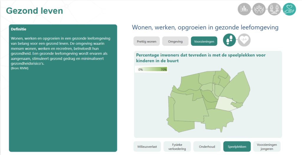
The Social Atlas
This platform brings together data from more than 250 sources — including CBS, RIVM, and municipal records — and turns it into actionable insights at the six-digit postal code level. In the Netherlands, this level of detail represents a small group of addresses that share the same six-digit code. As a result, policymakers gain an up-to-date and comprehensive view of their neighborhoods and districts, and can also compare these with other municipalities.
DMI Program Office
"The Social Atlas brings data to life: municipalities not only see what is going on, but can act directly and tailor policies to what is really needed."
Roy BoertienDMI Program Office
results and impact
The real value lies in the tangible results that municipalities can achieve with it. For example, they can now see data at the district level on issues such as obesity rates, debt problems, access to local facilities, and waiting lists in youth care. This allows them to develop more targeted policies and tailor their actions to the specific needs of each neighborhood. By presenting this information in a dashboard, municipalities can quickly get an overview of key issues or, if needed, explore more detailed information by district or theme.
calculate scenarios
An interesting feature of the Social Atlas is its ability to calculate different scenarios. For example: what happens as a neighborhood’s population ages? How does the demand for care change when more people start living alone? And what impact do high-rise buildings have on livability? By offering insight into these kinds of scenarios, municipalities can better anticipate future developments and adapt their policies accordingly. The Social Atlas also provides valuable input for new area developments, helping to determine the standards and requirements needed to keep a neighborhood healthy, affordable, and livable.
AI and dashboards for acceleration
The Social Atlas can also be enhanced with an AI assistant that helps users quickly find answers within policy documents, reports, and other unstructured data. For example, by asking a question like “How safe do people feel in this neighborhood?”, the AI assistant instantly provides relevant insights and policy options. This accelerates the policy-making process and supports integrated management of social themes.
Tangible results in the social domain
In the municipality of Alkmaar, the system is linked to the existing digital twin infrastructure. Here the digital twin is used to calculate scenarios and make targeted policy in the areas of livability, care and facilities.
In short, the Social Atlas makes the social domain both tangible and manageable. It provides municipalities not only with insight, but, more importantly, with a clear perspective for action. In this way, data truly becomes a driving force for social progress.
About Kurtosis and Clappform
Kurtosis is a data and analytics company active in both the social and physical domains. The company has extensive experience in business intelligence for municipalities and purchasing regions, as well as in conducting cost analyses and financial calculations within the social domain.
Clappform is a data governance and software company that primarily works with municipalities. It offers a solution for the social domain by connecting (open) data sources based on open data standards. These sources are technologically linked to the digital twin in accordance with the standards of the Open Geospatial Consortium.
join us make your offer visible to the entire network
We are here for governments, businesses, and knowledge institutions.